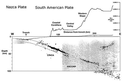
 Source: Allmendinger and González (2010)
Arica is a coastal city with approximately 190,000 residents located at 18° south latitude on the extreme northwestern edge of Chile. While historical earthquakes have indeed occurred within this region, little seismic activity has occurred here since 1877 because Arica resides within a seismic gap. This is generally not settling news since it represents a region where strain is and has been accumulating without release - meaning a considerable earthquake could hypothetically occur and Spence et al. (1999), and Berrocal et al (2004) have suggested that earthquakes in the late 1990s were precursors to a major event in the Arica 'elbow.' This is illustrated below as white ellipses, representing sections along the subduction zone that haven't experienced slip in the last century.
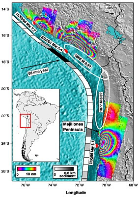 Source: Pritchard and Simmons (2006)
"as the only segment of the Chile-Peru Subduction Zone not to have ruptured within the last 100 years, the north Chile segment is now considered to be a region at high risk from an earthquake similar to, or larger than, the 1877 Tarapaca or Iquique earthquake (Mw 8.3)" - (Benfield 2010)
The last major event occurred in 1868 and completely leveled Arica and numerous coastal cities. This earthquake also produced a tsunami that added to both the local devastation and caused damage in New Zealand and Hawaii. This tsunami also left numerous ships stranded on land - similar to the events following the eruption of Krakatoa - such as the U.S. Wateree:
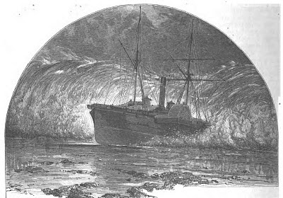 Source: Scribners Monthly
So I created some simple maps illustrating the tsunami inundation zone and historical earthquakes in the Arica region. To accomplish this I downloaded an inundation map produce by the Chilean Navy, exported the PDF as a tiff file and georeferenced it. Then I digitized the approximate boundary of the inundation zone and draped it over the topography (in relation to where I'm living and working) in ArcGIS and ArcScene to produce the following visualizations:

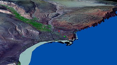 A simple 3D model illustrating how far both work and home are from the predicted inundation zone. The red flag represents the house, which is approximately 2.0 miles inland and the green flag is work and approximately 0.8 miles inland.
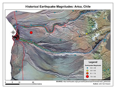
I created the earthquake magnitude maps by draping a Landsat image over a 30-m Aster-derived DEM and incorporating historical seismic data obtained from the USGS. This isn't very helpful other than illustrating how few earthquakes have occurred in this region since 1877. The large earthquake depicted in the center of the map represents the 1868 earthquake that caused so much devastation as depicted below:
 Source: U.S. Library of Congress
So, while the images are visually jolting there's no real way of predicting when an earthquake will occur so I won't - and hopefully friends and family won't - spend too much time worrying about what might happen. I would be more concerned if I was living in San Francisco given the height of their buildings; it is rare to find buildings over 3 stories in Arica and they are all downtown. I'm also confident that if an earthquake occurs that produces a tsunami, even if I'm within the inundation zone, I will have plenty of warning and time to flee the mile inland necessary to avoid harm. After living in Vermont for the last 7 years, I'm a little excited about living on an active margin and embrace all the possible processes that are at work beneath the city. So, to anyone out there who is worrying, don't!
Hiç yorum yok:
Yorum Gönder